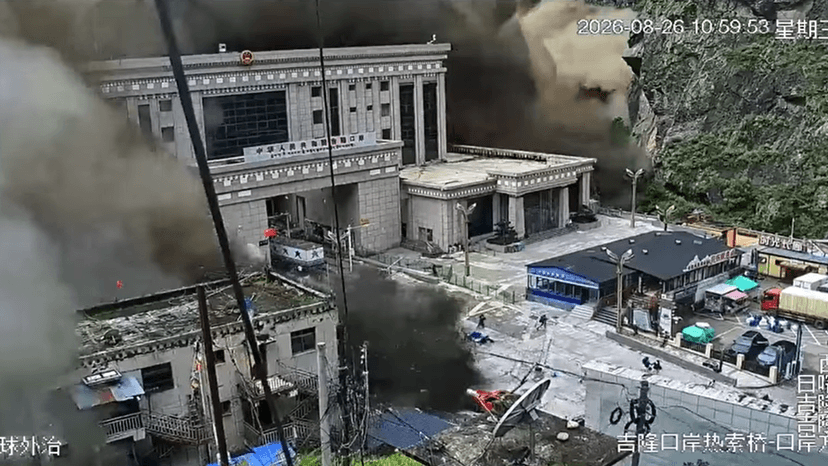
A glacier collapse near Langtang Lirung in the Himalayas triggered a catastrophic flash flood on the morning of August 26, sending a wall of mud, rock and meltwater roughly 72 kilometres down the Trishuli river valley and into settlements across seven Nepali districts — Rasuwa, Nuwakot, Dhading, Gorkha, Tanahun, Nawalparasi and Chitwan.
As of the latest figures from Nepal's disaster management authorities and Chinese officials in the Tibet Autonomous Region, the confirmed death toll has climbed past 800 across both countries, with more than 3,000 people still listed as missing. Nepal alone has recorded over 780 deaths and upward of 2,500 people unaccounted for, including several hundred foreign nationals; Chinese authorities have confirmed 16 deaths and 546 missing on their side of the border.
Scientists studying the disaster say a section of the Langtang Lirung glacier, roughly 600 metres wide, broke away cleanly and fell more than a kilometre to the valley floor, releasing debris that reportedly reached speeds near 50 metres per second. The impact registered as a magnitude 5.2 seismic event on monitoring stations, and the resulting flood destroyed the Gyirong Port border crossing between Nepal and Tibet within minutes.
The flood has cut off entire communities: officials say 32 bridges and nearly 25 miles of road were washed away, including the route connecting Betrawati in Nuwakot district to the Rasuwagadhi border crossing. Rescue teams have pulled roughly 3,700 people to safety so far, but poor weather and damaged access routes continue to slow search operations in the worst-hit areas.
More than 93,000 people are estimated to have been affected by the disaster. Authorities on both sides of the border say search and recovery work is ongoing, with the number of confirmed dead and missing expected to change as rescue teams reach areas that remain cut off.